|
Belize is located in the northern part of Central America along the western portion of the Caribbean, with Mexico and the base of the Yucatan Peninsula to the North and Guatemala to the west and south, the Caribbean Sea lies to the east. The country’s largest city as well as the Capital of Belize is Blemopan located at 17° 15 N, 88° 46 W.
Many Islands or Cayes (pronounced keys) as they are called in Belize can be found just off of the coast. The shallow offshore cayes straddle a coral reef 175 miles long which is second only in size to the Great Barrier Reef of Australia and is the longest in the Americas. Ambergris Cayes being the most developed for tourism. The reef has many beach formations, with snorkeling and diving being the big draw. Almost 58 miles east of Belize City lies the world famous Blue Hole, a very popular dive spot with an opening of 1000 feet across and around 400 feet deep.

The northern part of the coastline is low and swampy, with mangroves, many salt and freshwater lagoons and some sandy beaches. Numerous rivers cross the northern section. With more than 60% of Belize covered with rain forest one will find as they travel to the southwest the Maya mountain range and to the east the Mountain Pine Ridge. The highest peak is Victoria Peak at 3805 feet (1160 meters) The land to the west along the border with Guatemala is open and relatively scenic compared too much of the interior.
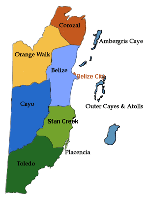
Belize is broken down into 6 districts, Belize, Cayo, Corozal, Orange Walk, Stann Creek and Toledo.
The climate of Belize has a steadily warm and humid tropical weather with a prominent rainy and dry season. The rainy season normally runs from June through December and the dry season from January to May. The south coastal area receiving the majority of rainfall. In the coastal areas the temperature will be in the range of the mid to upper 70’s year round. Higher temperatures are found in the Cayes or islands. The mountains will experience cooler temperatures.
The population of Belize as of July 2010 was 333,200. Belize is the least populated of all the Central American countries and out all countries in Latin America only Suriname and Guyana in the northern parts of South America are less densely populated.
With a strong British past, English is the official language spoken in Belize, making it the only country in Central America whose official language is English. Several other languages are spoken throughout Belize, the second most popular being Spanish, followed by Mayan, Garifuna and Creole
Many tourist and adventure seekers are drawn to Belize, with the second largest barrier reef in the world sprouting over 1000 cayes, fisherman, scuba divers and snorkelers are drawn to the crystal clear waters of the Caribbean. Inland adventure seekers as well as tourist will find numerous opportunities in rafting, exploring the lush jungles and Mayan Ruins that Belize has to offer.
The official currency of Belize is the Belizean Dollar (BZD), yet travelers will find that prices are usually quoted in U.S Dollars as well as accepted.
Getting to Belize is made easy with Belize City- Phillip SW Goldson International Airport (BZE) being just 10 miles from Belize City and just a short hop from the many cayes up and down the Caribbean Coast.
Belize has 3 main ports along the Caribbean Coast, the largest being the Port Of Belize located in Belize City, Big Creek Port located in the Stann Creek District and Commerce Bight Port.
|