Espanola Island Galapagos


The oldest island in the Galapagos Archipelago is Espanola Island. It is also known as Hood Island, and is a 10 to 12 hour boat ride from Isla Santa Cruz. Those planning to travel to this area should be aware that during the months of August and September the seas could be quite rough near the island. Espanola was formed through volcanic action, as were all of the Galapagos Islands. It is the oldest of the islands and testing revealed that the lava here is around 3.4 million years old. Today, the volcano on Espanola is extinct and because it is a rather low island, it is dry and quite inhospitable. However, this island is still a very popular tourist spot.
Because of Espanola’s hostile environment and lack of a large amount of fresh water, there are no settlements on the island. However, it is due to this lack of interference from humans that certain wildlife has been able to thrive by adjusting to the environment of the island.

For instance, the Marine Iguana from Espanola is the only one that changes its colors during breeding season, unlike those on the other Galapagos Islands. Normally, the iguanas are black, allowing them to hide in the black lava on each of the islands. However, the Espanola Marine Iguana is a reddish color, except during breeding season when it is a greenish shade.

The Hood Mockingbird is another animal that is endemic to Espanola. This bird is not afraid of visitors and at times even lands on a visitor’s head. In addition, it is the only carnivorous species of Mockingbird, thriving on a diet of insects and turtle hatchlings.

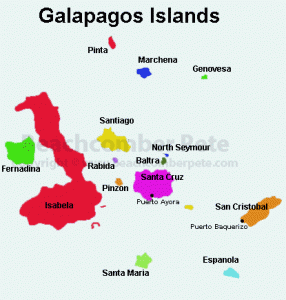
Map of Galapagos Islands

At one point, the Saddleback Tortoises of Espanola nearly went extinct. By 1959, there were only 12 females and 2 males left on the island. In the 1960’s, scientists brought these tortoises, along with another male tortoise from a U.S. zoo, to the Darwin Breeding Center where a captive breeding program began. Today, because of the success of that program, there is again a growing population of the Espanola Saddleback Tortoises.

Espanola’s greatest highlight is its many species of birds. The steep volcanic cliffs make perfect homes for many of them. The most popular, and one endemic to the island, is the Waved Albatross. The island has the largest population of these birds whose nests can be found only on Espana. It is quite a sight when these birds, with their enormous wingspan, take off from the high cliffs on their way to their feeding grounds. Those who enjoy bird watching will be thrilled by the variety of birds here including the Galapagos Hawks, Masked Boobies, Swallow Tailed Gulls and the Red Billed Tropic Bird.

Espanola has two visitor sites, Punta Suarez and Gardener Bay. Punta Suarez is on the western end of the island. Travelers must make a wet landing here. Walking along a two-mile trail, the visitor will be able to see sea lions playing in the water, numerous birds cavorting in the sky, and the largest Marine Iguanas in the Galapagos. This area is also home to the Espanola Lava Lizards, as well as birds such as the Galapagos Doves, the Large Billed Flycatcher, the Galapagos Hawk and the always popular Waved Albatross.


On the east side of Espanola is Gardiner Bay. This area is a popular site for swimming and snorkeling. Its white sand beach makes this the perfect spot to relax and enjoy the surroundings. There are colonies of sea lions who like to sun themselves on the beach, as well Green Sea Turtles just off shore. Nothing can beat snorkeling in Gardener Bay with the sea lions swimming right alongside. Out a little further, there are large schools of colored tropical fish along with an occasional Manta Ray and White Tipped Shark.

Although Espanola is not habitable according to human standards, it is the perfect home for a unique group of animals. They have been able to adapt to extreme conditions and many exist only on this island. A visit to Espanola allows the traveler to view an area unchanged by man, something that is becoming rarer as time goes by.
Galapagos Islands

Baltra

Espanola

Fernadina

Isabela

San Cristobal

Santa Cruz

Santa Maria

Santiago

Ecuador

Passport/Visa

Share

Santa Maria Island Galapagos


Of the 13 islands that make up the Galapagos Islands, Isla Santa Maria, also known as Floreana or Charles, is the sixth largest. It was formed from a single inactive volcano that many think is now extinct. It is going through the erosion process, which accounts for the rich soil there. This island has the fourth largest human settlement of the Galapagos, along with a history that includes whalers, pirates, buccaneers and convicts. The only way to reach this island is through a wet landing.

In the 17th and 18th centuries, pirates and whalers used Santa Maria as a haven because the island had a source of fresh water from a small spring. When they came to the island, they found giant tortoises and used them for food, causing a steep decline in the number of remaining tortoises. Foreigners also brought with them some goats and rats, which unfortunately added to the destruction of the native giant tortoises by eating their eggs. By 1840, that subspecies of tortoise became extinct.

The only settlement on Santa Maria is the tiny coastal town of Puerto Valasco Ibarra. Travelers are drawn to this town, often after reading about it in a book called “A Galapagos Affair.” This book follows the lives of the Wittmer family who were the original settlers in this town. Some of the family members are said to have died under mysterious circumstances, thus making a visit to this town even more intriguing. Santa Maria was the first of the Galapagos Islands to have a permanent settlement.

Map of Galapagos Islands

One site worth visiting, especially for its history, is Post Office Bay. In 1793, a whaling captain named James Colnett set up a wooden barrel to collect any mail needing to go back to England. In those times, whalers were away from their loved ones for long periods of time. Santa Maria Island had many ships stopping there either coming from or returning to England. Those coming from England would put letters in the barrel, and those returning to England would remove those letters to take with them as they traveled back to England. Even today, when a guest visits Post Office Bay, they are given some letters from the barrel to take home and mail, while adding their own letters to the barrel.

Also at Post Office Bay, the traveler can visit what is left of a Norwegian fishing village set up in 1926. Although those involved had hoped for a successful operation, it was not profitable and they abandoned it a few years later.

Another popular spot on Santa Maria Island is Punta Cormorant. This area boasts two beaches, one with green sand and the other with fine white sand. The green beach is good for snorkeling, as well as viewing sea lion colonies. Between the two beaches, the guest can follow a trail that leads to a lagoon where pink flamingoes and other birds make their home. These include birds such as large-billed flycatchers and ground finches. The trail ends at the white sand beach where ghost crabs and rays can be seen in the water. This beach is good for swimming as long as one avoids the rays.


One of the most popular areas of the Galapagos Islands is Devil’s Crown, found just off the coast of Punta Cormorant. This site was formed from a partially submerged volcano in the shape of a semicircle. Many consider it the best diving and snorkeling spot in the Galapagos. There are many species of brightly colored fish for the diver to swim with as well as sea lions, king angel fish, sea turtles and white-tipped sharks. The section of volcano above the water is home to many birds including pelicans, frigates and red-billed tropical birds that live in the crevices of the volcano.

A visit to Santa Maria Island offers the traveler many options, from walking and bird watching to snorkeling and scuba diving. With each activity, the guest will observe a unique aspect of the island while being transported back in time. Santa Maria is one island that all should endeavor to visit when traveling to this unique archipelago.

Galapagos Islands

Baltra

Espanola

Fernadina

Isabela

San Cristobal

Santa Cruz

Santa Maria

Santiago

Ecuador

Passport/Visa

Share

Baltra Island Galapagos


One of the smallest islands in the archipelago known as the Galapagos Islands is the Baltra Island, also known as South Seymour. The traveler can find this island near the center of the Galapagos. Like the other islands in the area, Baltra was formed from various forms of lava and land movement and it is approximately two million years old. For many years, the Galapagos Islands only airport was on this island. However, an additional airport has now been built on San Cristobal Island. In spite of this, the majority of tourist flights continue to land at the Baltra airport. Because of this, most cruise ships meet their customers at this airport and start their itinerary on Baltra Island.

It is interesting to note that Baltra Island has neither visitor sites nor accommodations for visitors. The available transportation is used only by those who come in by plane and need to reach their next mode of travel, either cruise ship or ferry. They will then be able to continue with their travels to the other islands.

Baltra’s history is a bit different from that of the other members of the Galapagos Islands. This island played a very important role during World War II. During this time, the U.S. Air Force set up a base on Baltra where they were joined by U.S. Navy patrols. Along with their submarine crews, their job was to keep watch for submarines in the waters of the Pacific Ocean, as well as to protect the Panama Canal. After the war ended, the base was handed over to Ecuador where it is now their official Naval Base. This is the reason that there are no visitor sites or accommodations on the island.

Baltra Island is a flat, dry island with few beaches. Volcanic cliffs surround most of the island. Like the other Galapagos Islands, the weather has two seasons. It has a hot season, which runs from December to May, and the dry season that runs from June to November. Although it looks desolate, there is some life to this island.

Because of the dry conditions, very few plants grow on Baltra. The only vegetation found there includes Prickly Pear cactus and Saltbushes. One may also find Opuntia cactus and Palo Santo trees. Other than these, there is very little vegetation.

When it comes to wildlife on the island, it is not so sparse. However, there are not nearly as many animals as can be found on the other islands. When the travelers arrive, they will be able to see birds such as the Galapagos Ground Finches, Frigate birds and brown pelicans. On the northern part of the island, one will find Mosaquera, which is a small sandy bank. It is here that a colony of sea lions can be found.

Map of Galapagos Islands

One very important animal connected with Baltra is the Baltra Land Iguana. In 1932-1933, some scientists removed 70 Land Iguanas from Baltra and took them to North Seymour Islet. Around the same time that the U.S. Air Force set up their base, the Land Iguanas native to Baltra became extinct. In 1980, some of the iguanas were taken from North Seymour Islet to Santa Cruz, where there was a captive breeding center for iguanas, the Charles Darwin Research Station. Luckily, they reproduced, and in 1991, some of these iguanas were returned to Baltra. As of 2007, there were 420 Baltra Land Iguanas living and breeding on the island. After landing at the airport on Baltra, the visitor can frequently see these iguanas near the runways.


As can be seen, Baltra Island is not as desolate as it may seem at first. Although it is not as open to the public as are the other islands, it still is a very important part of the Galapagos Islands. In addition to its importance in history, it is also the first island that most of the visitors walk on when traveling to this beautiful archipelago. When they arrive at the airport and see the Baltra Land Iguanas there to greet them, the travelers know that their trip to the Galapagos has just begun.

Galapagos Islands

Baltra

Espanola

Fernadina

Isabela

San Cristobal

Santa Cruz

Santa Maria

Santiago

Ecuador

Passport/Visa

Share

Santiago Island Galapagos


Santiago Island, also known as James Island or San Salvador, is centrally located in the archipelago of thirteen islands known as the Galapagos Islands. Due to its location, as well as numerous landing sites available, it is no wonder that this island has a place on the itinerary of most travelers visiting these islands.

This island, as with the other Galapagos Islands, was formed through the action of volcanoes. In the 1600s and 1700s, Santiago Island was a favorite hideout for pirates as well as a base for whalers. They would anchor their ships in one of the bays, and then go to the island to stock up on fresh water as well as tortoises to eat.

Spending time on Santiago Island is a rewarding experience, especially when traveling to the most popular areas of the island. There are three areas that visitors should try to see during their excursion to this island. The first is Puerto Egas, which one reaches by using a wet landing on the beach. Walking along the beach allows the visitor to view the best tide pools of the 13 islands. Here they can find creatures such as snails, hermit crabs and the Four-Eyed Blenny.

From the beach, the travelers have a choice of two trails to follow. The first takes them inland to the site of a salt crater which, before the 1950s, was used as a salt mine. However, that endeavor was a failure and the site was abandoned. When visiting the area, one can still see some of the equipment left behind. Bird lovers will enjoy this trail as it gives them a chance to view endemic Galapagos hawks as well as Darwin finches and other native birds.

By taking the second trail, the visitor will come to the Fur Seal Grotto, where they can obtain a close up view of fur seals as well as sea lions. The Galapagos Fur Seals are the smallest of the fur seals and were hunted almost to extinction. During the heat of the day, they rest in the small ledges and caves of the lava cliffs, and at night, they feed on fish and squid. With the clear water and the sea lions and seals nearby, many find this area one of their favorites for snorkeling and swimming.

Map of Galapagos Islands

Another destination worth visiting on Santiago Island is Sullivan Bay. It lies on the eastern side of the island, where a large lava flow took place in an eruption in 1897. Because of its composition, the hardened lava looks like it is still molten, and many enjoy walking along this artistic landscape. The only plant found here is the Mollugo plant, and even now, it is very rare. Due to the quickness of the lava flow during the eruption, there are molds of tree trunks, left when the lava surrounded the trunk and incinerated the wood inside. The only thing that remained was the hardened lava that covered it.

North of Puerto Egas, one will find Buccaneer’s Cove. This was a haven for the buccaneers, pirates and whalers in the 18th and 19th centuries. The cove consists of steep cliffs and red-purple sand. Many venture here for the magnificent view. Living among the cliffs one will find large numbers of sea birds.

Not far from Buccaneer’s Cove, one will find Espumilla Beach. Due to changes caused by the El Nino weather feature, the lagoons originally present have disappeared along with the flamingo colony that lived there. However, the area is still important because it is the nesting site for the marine turtles, a very important aspect of the tourism economy of the area.


From far away, Santiago Island looks empty and desolate. However, once a visitor steps foot on the island, it magically comes to life. From the view of the salt crater and the machinery used in that endeavor, to the varied forms of the lava flows, to the unique plants and animals that call this island home, this island is one that the traveler should not overlook. Otherwise, they will be missing sights found nowhere but on Santiago Island.

Galapagos Islands

Baltra

Espanola

Fernadina

Isabela

San Cristobal

Santa Cruz

Santa Maria

Santiago

Ecuador

Passport/Visa

Share

Fernandina Island Galapagos


On the western side of the Galapagos Islands lies the youngest of the Islands, Fernandina Island. This island, named in honor of King Fernando from Spain, is located on the western edge of the archipelago. As the youngest of the 13 Galapagos Islands, scientists put its age at approximately 700,000 years old.

Fernandina Island, formed as a result of volcanic activity, is one of the most active of the islands, with eruptions occurring every few years. Due to this action, changes sometimes take place in regards to the plant and animal life on the island. For instance, in 1968 an eruption of the volcano caused the caldera to drop 1000 feet when it collapsed. At other times, the eruption of the volcano has caused the lake to change position in the caldera. The flow of lava during an eruption also has an effect on the status of the island.

Fernandina Island is one of the few Islands that has had no native plant or animal species introduced by man. Instead, all of the plant and animal life came to the island through nature. Although the island looks desolate with its rocky landscape and lack of abundant animal life, Fernandina does have some secrets to share with the visitor.

On the northeast coast of Fernandina Island one will find the dock used to gain access to the island. However, it can be used only during high tide. During low tide, the landing takes place on volcanic rock. One must walk carefully due to the fragile state of the lava and fissures. From this point, called Punta Espinoza, the visitor has the best chance to see the flora and fauna of this island.

One trail takes the hiker to the lava fields, allowing them to have access to recent volcanic activity. If they look carefully, they will be able to see lava cactus, one of the few plants that survives here. Mangroves can be found growing in this area as well.

Map of Galapagos Islands

This trail, also known as the Land’s End trail, then leads the visitor to a patch of land that is home to several species of animals. Fernandina boasts the largest colony of marine iguanas, looking as if they are guarding the coast of the island. These iguanas are the only such lizards to adapt to living in an area where they have to get their food, seaweed and algae, from the sea, rather than from land plants as do other lizards.

Following the trail that is the closest to the point of the island will take the visitor to a colony of sea lions. The male sea lions defend their territory, and their barks cannot be missed. In addition, the flightless cormorants build their nests in the rough areas above the water line. The Galapagos Penguins are also starting to nest in this area.


Other animals found on Fernandina Island include herons, pelicans, Yellow Warblers, and the Mangrove finch. When visiting this island, it is very important to stay on the trails, as well as to avoid bringing any foreign species of plant or animal to the island.

From afar, Fernandina Island looks like a bleak and barren island. However, upon arriving on its shore, and with a little bit of exploration, the visitor will find hidden sights, flora and fauna that cannot be seen until they step foot on the black sand. Although this island is not one of the most popular for short cruises, when one has the time to explore, Fernandina Island is well worth the time spent there.

Galapagos Islands

Baltra

Espanola

Fernadina

Isabela

San Cristobal

Santa Cruz

Santa Maria

Santiago

Ecuador

Passport/Visa

Share

Map of Galapagos Islands

The Galapagos Islands located along the equator , sitting just 525 miles out into the Pacific Ocean off the western coast of South America and the country of Ecuador, this archipelago is made up of 60 named volcanic islands.

With a population of just over 23,000 residents, the Galapagos Islands have become a major tourist draw, today, the islands made famous by Charles Darwin and his theory of evolution have transformed the Galapagos into a biological marine reserve, a national park as well as a Ecuadorian province.

map-galapagos-islands

Fernandina Island Santa Maria Espanola Island Santiago Island Baltra Island

Galapagos Islands

Baltra

Espanola

Fernadina

Isabela

San Cristobal

Santa Cruz

Santa Maria

Santiago

Ecuador

Passport/Visa

Share

Isabela Island Galapagos


About 1000 km from the coast of Ecuador, one will find the group of islands known as the Galapagos Islands. This archipelago consists of 13 islands formed by volcanic activity. The largest of these islands is Isabela, which is also the youngest at approximately 1 million years old. With a shape similar to a seahorse, the northern part of Isabela lies across the equator. The island was formed from six volcanoes, with five of the volcanoes still active and two of them situated on the equator itself.

Isabela, which was discovered by Christopher Columbus, was named for Queen Isabela, who funded his voyages. Because of the bays and high cliffs, pirates and buccaneers found this island a perfect place to hide. Today, this island is accessible by both plane and cruise ship. 

Click for Larger Map of Galapagos Island

Due to the location of Isabela Island Galapagos, the weather is controlled by the wind and ocean currents near the island. June through December is known as the dry season, with short mid-day showers but usually clear skies. During this time, the colder ocean currents run closer to the island and the land animals and sea mammals are at their most active. December through May is the warm season, which finds the island with more rain and clouds. The ocean currents become warmer close to the island, which makes the water perfect for snorkeling and swimming. In addition, the birds on Isabel are at their most active at this time.

Many people know about Charles Darwin’s connection to the Galapagos Islands. He developed the theory of natural selection, based on the many different types of plants and animals he found there. The most well known and most visited area is that where the Galapagos Tortoises live. On Isabela Island, they prefer to live in the calderas of the various volcanoes. Those wishing to view other animals on this island will not be disappointed. In addition to the famous tortoises, animals such as marine and land iguanas can be found on this island.

Those whose main interest is birding will also enjoy a visit to Isabela Island. Among the birds they may see are the Galapagos Penguins, as well as flightless cormorants, blue footed boobies and pelicans in the various bay areas. Most of these can be found along the coast of Isabela. Other birds found on the island include the Galapagos Hawks, brown pelicans, and pink flamingos.


For those visiting Isabela Island for swimming and diving activities, they too will have a wonderful experience. They will be able to view Galapagos penguins, whales, dolphins and marine turtles swimming off the coast of this amazing island. At times, it is even possible to swim along with the penguins.

When traveling to the Galapagos Islands, either by cruise ship or plane, the visitor should definitely schedule a large block of time to spend on Isabela Island. They will need this extra time to allow them to view all these unique sites, along with the other flora and fauna that makes Isabela Island one of the most beautiful islands of the archipelago.

Galapagos Islands

Baltra

Espanola

Fernadina

Isabela

San Cristobal

Santa Cruz

Santa Maria

Santiago

Ecuador

Passport/Visa

Share